Melbourne Sets New All-Time February Record Low at 25 Degrees
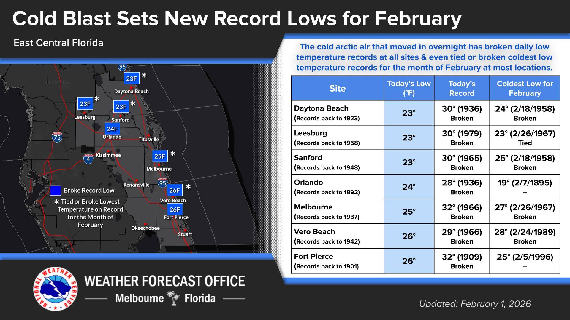
BREVARD COUNTY, FLORIDA – A historic Arctic outbreak swept across Central Florida, plunging temperatures to levels rarely seen in the region and shattering daily and all-time February records at every National Weather Service Melbourne climate site.
In Melbourne, the temperature dropped to 25 degrees Fahrenheit, establishing a new all-time February record low. The previous record of 27 degrees had stood since 1967, making the new mark a significant milestone in local weather history.
Forecasters at the NWS in Melbourne said the extreme cold resulted from a powerful Arctic air mass that surged deep into the southeastern United States, bringing unusually frigid conditions to a region better known for mild winters.
“This event is historic for east-central Florida,” meteorologists said. “It is rare for temperatures this low to reach the Space Coast, and even more unusual for records to be broken simultaneously across all of our climate sites.”
VIDEO: A historic Arctic outbreak swept across Central Florida, plunging temperatures to levels rarely seen in the region and shattering daily and all-time February records at every National Weather Service Melbourne climate site.
Widespread Record-Breaking Cold
The record-setting temperatures were not limited to Melbourne. Climate observation sites throughout Brevard, Orange, Volusia, Lake, and Osceola counties reported new daily and February record lows, highlighting the breadth and intensity of the cold snap.
Overnight lows fell well into the 20s in several inland locations, while coastal areas — typically moderated by ocean influence — also experienced temperatures near or below freezing.
The prolonged cold was especially notable, with subfreezing conditions persisting for multiple hours in some communities, increasing the risk of frost and freeze damage.
The bitter cold prompted a series of weather alerts, including Extreme Cold Warnings, Freeze Warnings, and Wind Advisories. Emergency management officials urged residents to take precautions to protect people, pets, plants, and property.
“Reaching the mid-20s in Melbourne is exceptional,” NWS Melbourne stated. “This type of cold is something we typically associate with states much farther north.”
NEXT WEEK’S FORECAST
The post Deep Freeze Hits Space Coast as Melbourne Breaks 59-Year February Cold Record appeared first on Space Coast Daily.